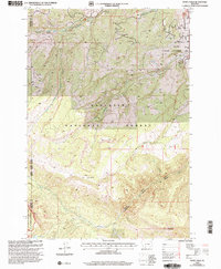
2000 Map of Ousel Falls
USGS Topo · Published 2005About this map
The Gallatin River and its intricate tributaries dominate this high-elevation landscape, where the South Fork West Fork Gallatin River meets the main stem. This area serves as a critical junction of wilderness management, bounded by the Gallatin National Forest, the Lee Metcalf Wilderness, and the Gallatin Wildlife Management Area. Human presence is marked by high-altitude infrastructure, notably the Cinnamon Lookout atop Cinnamon Mountain and a remote Communication Site. Small-scale resource extraction is indicated by several Prospects and a Gravel Pit near the Lower Basin. The complex drainage patterns of Buck Creek and Little Hell Roaring Creek carve through the terrain, leading toward the landmark Ousel Falls and the secluded Lizard Lakes.
Find a feature on this map
23 named features on this map. Tap any name to fly to it.
Don’t see what you’re looking for? This feature index may not catch every label — zoom into the map to look around manually.
Map Details
Editions of this 2000 Ousel Falls Map
This is the sole edition of this map. No revisions or reprints were ever made.
Other maps of this area

1888 · Three Forks
USGS Topo · 1:250,000

1894 · Three Forks
USGS Topo · 1:250,000

1895 · Three Forks
USGS Topo · 1:250,000

1947 · Bozeman
USGS Topo · 1:250,000

1948 · Bozeman
USGS Topo · 1:250,000

1950 · Spanish Peaks
USGS Topo · 1:62,500

1950 · Sphinx Mountain
USGS Topo · 1:62,500

1955 · Bozeman
USGS Topo · 1:250,000

1955 · Garnet Mountain
USGS Topo · 1:62,500

1955 · Crown Butte
USGS Topo · 1:62,500