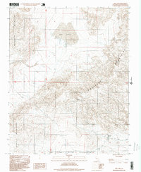
1996 Map of Owl Lake
USGS Topo · Published 1999About this map
Owl Lake sits at the heart of this desert landscape, framed by the stark topography of the Owlshead Mountains to the north and the Quail Mountains to the south. This area, largely encompassed by the Fort Irwin Military Reservation, reveals a history of mid-century extraction and desert transit. The map documents industrial sites like the Black Magic Mine and New Deal Mine, tucked into the folds of the southern Owlshead range. These mines, along with the Owl Hole Springs Ruins, point to a period when remote water sources and mineral deposits dictated the sparse human footprint in this corner of San Bernardino County. Transportation is limited to rugged tracks such as Randsburg Road and Owl Hole Springs Road, which served these isolated outposts during the later decades of the twentieth century.
Find a feature on this map
11 named features on this map. Tap any name to fly to it.
Don’t see what you’re looking for? This feature index may not catch every label — zoom into the map to look around manually.
Map Details
Editions of this 1996 Owl Lake Map
This is the sole edition of this map. No revisions or reprints were ever made.
Other maps of this area

1933 · Avawatz Mountains
USGS Topo · 1:250,000

1947 · Trona
USGS Topo · 1:250,000

1948 · Trona
USGS Topo · 1:250,000

1948 · Quail Mountains
USGS Topo · 1:62,500

1948 · Leach Lake
USGS Topo · 1:62,500

1950 · Wingate Wash
USGS Topo · 1:62,500

1950 · Confidence Hills
USGS Topo · 1:62,500

1951 · Quail Mountains
USGS Topo · 1:62,500
1951 · Leach Lake
USGS Topo · 1:62,500

1953 · Trona
USGS Topo · 1:250,000