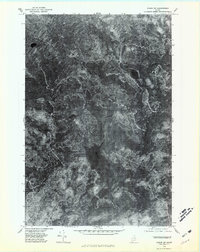
1975 Map of Oxbow SW
USGS Topo · Published 1981About this map
Umcolcus Lake dominates this 1970s orthophotoquad, serving as the central drainage for a dense Maine forest network. Unlike traditional topographic maps, this imagery-based survey uses rectified aerial photography from October 1975 to document the landscape’s exact texture, showing the meandering path of the East Branch Umcolcus Stream as it winds through wetlands and marshy inlets. This specific format captures the state of the timberland during the mid-1970s, revealing clearings, logging tracks, and natural water bodies like Cranberry Pond and Beaver Pond without the abstraction of contour lines. The elevation at Oak Hill and the seasonal water levels of Boody Brook are preserved exactly as they appeared to the camera, providing a rare high-fidelity record of this Penobscot County wilderness before decades of modern forest management changed the canopy patterns.
Find a feature on this map
6 named features on this map. Tap any name to fly to it.
Don’t see what you’re looking for? This feature index may not catch every label — zoom into the map to look around manually.
Map Details
Editions of this 1975 Oxbow SW Map
This is the sole edition of this map. No revisions or reprints were ever made.
Other maps of this area

1940 · Island Falls
USGS Topo · 1:62,500

1940 · Oxbow
USGS Topo · 1:62,500

1942 · Island Falls
USGS Topo · 1:62,500

1942 · Oxbow
USGS Topo · 1:62,500

1954 · Shin Pond
USGS Topo · 1:62,500

1954 · Grand Lake Seboeis
USGS Topo · 1:62,500

1954 · Presque Isle
USGS Topo · 1:250,000

1958 · Presque Isle
USGS Topo · 1:250,000

1960 · Presque Isle
USGS Topo · 1:250,000
1965 · Oxbow
USGS Topo · 1:62,500