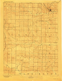
1894 Map of Oxford
USGS Topo · Published 1910About this map
Oxford stands as the primary rail hub of this late 19th-century Iowa landscape, situated at the junction of the Chicago Rock Island and Pacific Railroad and local waterways. The map reveals a highly structured agricultural grid, where townships like Hardin, York, and Greene are dissected by a network of drainage systems. The water table is central to the area's layout, with Old Mans Creek and the North English River carving through the terrain alongside smaller tributaries like Deer Creek and Teener Creek. To the east, the small settlement of Windham provides a secondary point of community life. This survey, conducted under the direction of Henry Gannett and W. J. Peters, preserves the specific nineteenth-century property and transportation corridors before the heavy modernization of the rural Midwest, including the western path of the Chicago Milwaukee and St. Paul Railroad through Fillmore.
Find a feature on this map
21 named features on this map. Tap any name to fly to it.
Don’t see what you’re looking for? This feature index may not catch every label — zoom into the map to look around manually.
Map Details
Editions of this 1894 Oxford Map
2 editions found
Other maps of this area

1887 · Cedar Rapids
USGS Topo · 1:62,500

1888 · Amana
USGS Topo · 1:62,500

1889 · Amana
USGS Topo · 1:62,500

1891 · Oxford
USGS Topo · 1:62,500

1891 · Cedar Rapids
USGS Topo · 1:62,500

1891 · Iowa City
USGS Topo · 1:62,500

1894 · Oxford
USGS Topo · 1:62,500

1899 · Amana
USGS Topo · 1:62,500

1903 · Fairfax
USGS Topo · 1:125,000
1938 · Iowa City
USGS Topo · 1:62,500