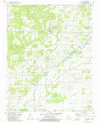
1979 Map of Oxly
USGS Topo · Published 1980About this map
Little Black River meanders through the central and southern reaches of this Ripley County landscape, defining the local geography alongside its various tributaries and the Cypress Ditch drainage system. The settlement of Oxly serves as a focal point near the Missouri Pacific railroad line, which cuts across the northern terrain. This late-1970s survey preserves the locations of numerous rural institutions that served the scattered homesteads of the area, including the Antioch Ch and New Hope Ch. A deep history of transit is evident in the presence of the Military Road and the Old RR Gr, tracing former corridors of movement through Turkeypen Hollow and across the ridges. Genealogists will find a wealth of family-history landmarks, from the Stillwell Cem to the Kelsey Cem, marking the long-standing community footprint near the state border.
Find a feature on this map
43 named features on this map. Tap any name to fly to it.
Don’t see what you’re looking for? This feature index may not catch every label — zoom into the map to look around manually.
Map Details
Editions of this 1979 Oxly Map
This is the sole edition of this map. No revisions or reprints were ever made.
Other maps of this area

1935 · Acorn
USGS Topo · 1:62,500

1935 · Knobel
USGS Topo · 1:62,500

1935 · Reyno
USGS Topo · 1:62,500

1939 · Doniphan
USGS Topo · 1:62,500

1940 · Naylor
USGS Topo · 1:62,500

1941 · Knobel
USGS Topo · 1:62,500

1944 · Naylor
USGS Topo · 1:62,500

1945 · Doniphan
USGS Topo · 1:62,500

1957 · Poplar Bluff
USGS Topo · 1:250,000

1959 · Poplar Bluff
USGS Topo · 1:250,000