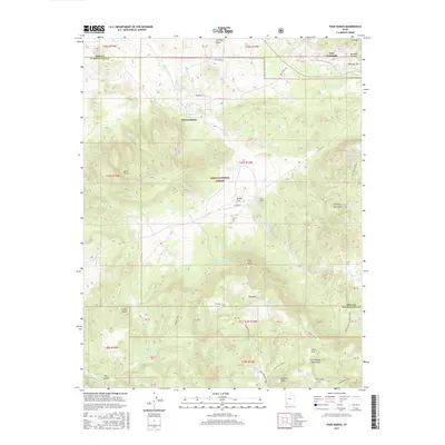
2017 Map of Page Ranch
USGS Topo · Published 2017About this map
Old Irontown and the nearby Page Ranch sit at the center of this Iron County survey, where the high desert landscape meets the northern reaches of the Dixie National Forest. This area was historically defined by its mineral wealth, evidenced by the large Blowout Pit on Iron Mountain and the remains of early smelting operations. The map provides a clear look at the water sources that sustained ranching and mining in this arid region, including Lamb Reservoir, Paradise Reservoir, and numerous springs like Kane Spring and Cottonwood Spring. To the south, the terrain rises into the Pine Valley Mountains, where peaks like Rencher Peak and Pinto Peak overlook isolated features such as The Dairy and Richie Flat. A network of historic paths, including the Summit Trail and Rock Springs Trail, weaves through the canyons and high-elevation plateaus.
Find a feature on this map
54 named features on this map. Tap any name to fly to it.
Don’t see what you’re looking for? This feature index may not catch every label — zoom into the map to look around manually.
Map Details
Editions of this 2017 Page Ranch Map
This is the sole edition of this map. No revisions or reprints were ever made.
Other maps of this area

1885 · St. George
USGS Topo · 1:250,000

1891 · St. George
USGS Topo · 1:250,000

1950 · Iron Mountain
USGS Topo · 1:62,500

1950 · Stoddard Mtn
USGS Topo · 1:24,000

1950 · Silver Peak
USGS Topo · 1:24,000

1950 · Desert Mound
USGS Topo · 1:24,000

1950 · Page Ranch
USGS Topo · 1:24,000

1951 · Silver Peak
USGS Topo · 1:24,000
1951 · Desert Mound
USGS Topo · 1:24,000

1951 · Stoddard Mtn
USGS Topo · 1:24,000