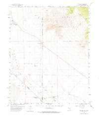
1958 Map of Pahrump
USGS Topo · Published 1965About this map
The settlement of Pahrump and its early agricultural landscape are documented in this mid-century survey, conducted when the area was characterized by scattered ranching operations and water-dependent landmarks. The map shows the Pahrump Ranch and Manse Ranch as central hubs of activity in the Pahrump Valley, supported by essential water sources like Mound Spring and an Artesian Well. Educational infrastructure is represented by the Rose Sch, while the isolated Hidden Hills Ranch and a nearby Landing Strip indicate the beginning of more modern developments in this high desert environment.
Find a feature on this map
22 named features on this map. Tap any name to fly to it.
Don’t see what you’re looking for? This feature index may not catch every label — zoom into the map to look around manually.
Map Details
Editions of this 1958 Pahrump Map
2 editions found
Other maps of this area

1907 · Las Vegas
USGS Topo · 1:250,000

1908 · Furnace Creek
USGS Topo · 1:250,000

1908 · Las Vegas
USGS Topo · 1:250,000

1910 · Furnace Creek
USGS Topo · 1:250,000

1910 · Ivanpah
USGS Topo · 1:250,000

1912 · Ivanpah
USGS Topo · 1:250,000

1933 · Avawatz Mountains
USGS Topo · 1:250,000

1942 · Ivanpah
USGS Topo · 1:250,000

1947 · Trona
USGS Topo · 1:250,000

1947 · Kingman
USGS Topo · 1:250,000