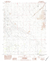
1984 Map of Pahrump
USGS Topo · Published 1984About this map
Pahrump Valley serves as the focal point for this mid-1980s survey, documenting a period of suburban expansion into the arid basin. The map illustrates a transitional landscape where the rigid grid of modern development, represented by routes like Thousandaire Blvd and Calvada Blvd, meets the older ranching and agricultural roots of the area. A sprawling Golf Course and residential streets such as Dandelion Street sit adjacent to Gravel Pits and various Borrow Pits, indicating active construction and resource extraction.
Find a feature on this map
34 named features on this map. Tap any name to fly to it.
Don’t see what you’re looking for? This feature index may not catch every label — zoom into the map to look around manually.
Map Details
Editions of this 1984 Pahrump Map
This is the sole edition of this map. No revisions or reprints were ever made.
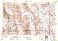
Other maps of this area

1907 · Las Vegas
USGS Topo · 1:250,000

1908 · Furnace Creek
USGS Topo · 1:250,000

1908 · Las Vegas
USGS Topo · 1:250,000

1910 · Furnace Creek
USGS Topo · 1:250,000

1948 · Death Valley
USGS Topo · 1:250,000

1954 · Las Vegas
USGS Topo · 1:250,000

1954 · Death Valley
USGS Topo · 1:250,000

1956 · Death Valley
USGS Topo · 1:250,000

1957 · Las Vegas
USGS Topo · 1:250,000
1957 · Death Valley
USGS Topo · 1:250,000