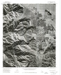
1975 Map of Palm Springs
USGS Topo · Published 1977About this map
Palm Springs is shown here during a period of significant mid-century expansion, captured through orthophotoimagery that reveals the sharp contrast between the dense residential grids of the desert floor and the steep rising shadows of the San Jacinto mountains. The Whitewater River defines the northeastern boundary of the developed area, while the interior of the town is bisected by the diagonal path of Tahquitz Creek. This 1975 survey, produced in cooperation with the Soil Conservation Service, provides an aerial perspective on the urban layout, including the prominent runways of the Palm Springs Airport and the seasonal drainages like Palm Canyon Wash. The map documents the intricate patterns of golf courses, swimming pools, and planned subdivisions that transformed this arid landscape into a major resort destination.
Find a feature on this map
5 named features on this map. Tap any name to fly to it.
Don’t see what you’re looking for? This feature index may not catch every label — zoom into the map to look around manually.
Map Details
Editions of this 1975 Palm Springs Map
This is the sole edition of this map. No revisions or reprints were ever made.
Other maps of this area

1901 · Southern California Sheet No. 1
USGS Topo · 1:250,000

1901 · San Jacinto
USGS Topo · 1:125,000

1904 · Indio
USGS Topo · 1:125,000

1904 · Southern California Sheet No. 1
USGS Topo · 1:250,000

1940 · Palm Springs
USGS Topo · 1:62,500

1940 · Hemet Reservoir
USGS Topo · 1:62,500

1941 · Toro Peak
USGS Topo · 1:62,500

1941 · Edom
USGS Topo · 1:62,500

1942 · Hemet Reservoir
USGS Topo · 1:62,500

1944 · Toro peak
USGS Topo · 1:62,500