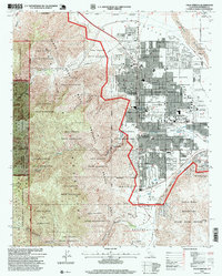
1996 Map of Palm Springs
USGS Topo · Published 1999About this map
Palm Springs and its surrounding desert canyons appear in high detail during the late 1990s, showcasing the distinct grid of the city against the backdrop of the San Jacinto Mountains. The map reveals the intricate checkerboard land ownership patterns within the Agua Caliente Indian Reservation, where urban development alternates with open desert and mountain terrain. Key municipal sites like the Palm Springs Municipal Airport and Mesquite Country Club illustrate the region's mid-century growth as a premier destination.
Find a feature on this map
53 named features on this map. Tap any name to fly to it.
Don’t see what you’re looking for? This feature index may not catch every label — zoom into the map to look around manually.
Map Details
Editions of this 1996 Palm Springs Map
This is the sole edition of this map. No revisions or reprints were ever made.
Other maps of this area

1901 · Southern California Sheet No. 1
USGS Topo · 1:250,000

1901 · San Jacinto
USGS Topo · 1:125,000

1904 · Indio
USGS Topo · 1:125,000

1904 · Southern California Sheet No. 1
USGS Topo · 1:250,000

1940 · Palm Springs
USGS Topo · 1:62,500

1940 · Hemet Reservoir
USGS Topo · 1:62,500

1941 · Toro Peak
USGS Topo · 1:62,500

1941 · Edom
USGS Topo · 1:62,500

1942 · Hemet Reservoir
USGS Topo · 1:62,500

1944 · Toro peak
USGS Topo · 1:62,500