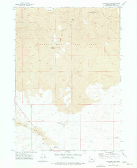
1972 Map of Palomino Lake
USGS Topo · Published 1975About this map
The Saddle Butte Lava Field dominates this volcanic landscape in Malheur County, characterized by a complex network of geological formations and subterranean features. Surveyed in the early 1970s, the terrain is marked by distinctive subterranean landmarks such as Tire Tube Cave and Coyote Trap Cave, alongside a prominent Lava Tube and the topographic high point of Saddle Butte.
Find a feature on this map
15 named features on this map. Tap any name to fly to it.
Don’t see what you’re looking for? This feature index may not catch every label — zoom into the map to look around manually.
Map Details
Editions of this 1972 Palomino Lake Map
This is the sole edition of this map. No revisions or reprints were ever made.
Other maps of this area

1955 · Jordan Valley
USGS Topo · 1:250,000

1955 · Burns
USGS Topo · 1:250,000

1955 · Adel
USGS Topo · 1:250,000

1955 · Boise
USGS Topo · 1:250,000

1957 · Adel
USGS Topo · 1:250,000

1957 · Jordan Valley
USGS Topo · 1:250,000

1958 · Burns
USGS Topo · 1:250,000

1958 · Boise
USGS Topo · 1:250,000

1958 · Adel
USGS Topo · 1:250,000

1958 · Jordan Valley
USGS Topo · 1:250,000