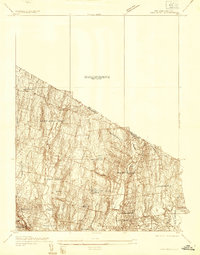
1934 Map of Park Ridge
USGS Topo · Published 1934About this map
Woodcliff Lake and its surrounding reservoirs define this section of Bergen County during the mid-1930s, reflecting a landscape transitioning from rural estates to more structured suburban settlements. The topography is dominated by the ridges that give Park Ridge its name, with the New York and New Jersey state line cutting diagonally across the northern portion of the map. Local industry and utility are represented by features like the Western Reservoir and Mill Pond, while the presence of Villa Maria Clare indicates the era's institutional development. A prominent transmission line and the corridor of Chestnut Ridge Road suggest the early infrastructure supporting the growth of Upper Saddle River and Montvale. Genealogists and historians can trace the specific street layouts and property boundaries that shaped these communities before the massive post-war expansion of the New York metropolitan area.
Find a feature on this map
29 named features on this map. Tap any name to fly to it.
Don’t see what you’re looking for? This feature index may not catch every label — zoom into the map to look around manually.
Map Details
Editions of this 1934 Park Ridge Map
This is the sole edition of this map. No revisions or reprints were ever made.
Other maps of this area

1888 · Paterson
USGS Topo · 1:62,500

1891 · Ramapo
USGS Topo · 1:62,500

1891 · Harlem
USGS Topo · 1:62,500

1892 · Paterson
USGS Topo · 1:62,500

1892 · Tarrytown
USGS Topo · 1:62,500

1893 · Tarrytown
USGS Topo · 1:62,500

1893 · Ramapo
USGS Topo · 1:62,500

1897 · Harlem
USGS Topo · 1:62,500

1898 · Harlem
USGS Topo · 1:62,500

1898 · Paterson
USGS Topo · 1:62,500