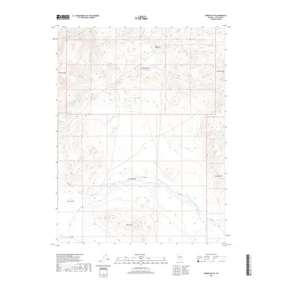
2018 Map of Parker Butte
USGS Topo · Published 2018About this map
The lowlands of Mason Valley define the southwestern portion of this Lyon County survey, where the terrain transitions from the high peaks of the Desert Mountains toward the agricultural flats of the river basin. The settlement of Lux sits near the southern edge of the sheet, providing a specific point of reference for researchers tracing the historical development of transport and ranching in this part of Nevada. The landscape is characterized by the prominent elevation of Parker Butte, which rises as a distinct landmark above the surrounding valley floor. This topography, marked by numerous dry washes and seasonal springs like Buzz Point Spring, reflects the arid character of the western Great Basin. The Walker River meanders through the central and southern sections, its course dictating the placement of early roads such as Julian Ln and shaping the region's limited settlement patterns.
Find a feature on this map
2 named features on this map. Tap any name to fly to it.
Don’t see what you’re looking for? This feature index may not catch every label — zoom into the map to look around manually.
Map Details
Editions of this 2018 Parker Butte Map
This is the sole edition of this map. No revisions or reprints were ever made.
Other maps of this area

1891 · Wabuska
USGS Topo · 1:125,000

1894 · Wabuska
USGS Topo · 1:125,000

1908 · Carson Sink
USGS Topo · 1:250,000

1910 · Carson Sink
USGS Topo · 1:250,000

1951 · Weber Reservoir
USGS Topo · 1:62,500

1951 · Fallon
USGS Topo · 1:62,500

1957 · Wabuska
USGS Topo · 1:62,500

1957 · Silver Springs
USGS Topo · 1:62,500

1957 · Reno
USGS Topo · 1:250,000

1959 · Reno
USGS Topo · 1:250,000