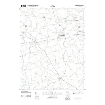
2010 Map of Parkesburg
USGS Topo · Published 2010About this map
The borough of Parkesburg serves as a central hub in this corner of Chester County, surrounded by a landscape of small agricultural settlements and historically significant meeting places. To the west, the towns of Atglen and Christiana mark the corridor toward Lancaster County, while the Sadsbury Meeting House and Upper Octoraro church stand as landmarks of long-standing community foundations. The terrain is intricately carved by several waterways, including Valley Creek and the East Branch Octoraro Creek, which historically supported local industry as evidenced by the Parkesburg Iron Company Dam. From the crossroads of Cochranville in the south to the clustered heights of Pomeroy Heights in the east, the map reveals a network of old roads like Strasburg Rd and Limeville Rd that continue to define the movement through this rural-to-suburban landscape.
Find a feature on this map
93 named features on this map. Tap any name to fly to it.
Don’t see what you’re looking for? This feature index may not catch every label — zoom into the map to look around manually.
Map Details
Editions of this 2010 Parkesburg Map
This is the sole edition of this map. No revisions or reprints were ever made.
Other maps of this area

1904 · Coatesville
USGS Topo · 1:62,500

1905 · Honey Brook
USGS Topo · 1:62,500

1906 · Coatesville
USGS Topo · 1:62,500

1906 · New Holland
USGS Topo · 1:62,500

1907 · Honeybrook
USGS Topo · 1:62,500

1908 · New Holland
USGS Topo · 1:62,500

1912 · Quarryville
USGS Topo · 1:62,500

1918 · Coatesville
USGS Topo · 1:62,500

1941 · Honeybrook
USGS Topo · 1:62,500

1941 · New Holland
USGS Topo · 1:62,500