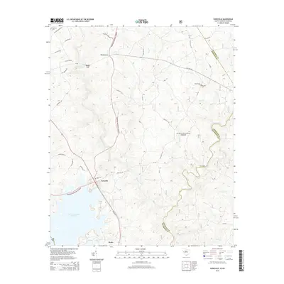
2014 Map of Parksville
USGS Topo · Published 2014About this map
Parksville and Modoc sit along the western edge of the South Carolina piedmont, positioned where the terrain descends toward the wide J. Strom Thurmond Reservoir. This landscape is defined by the transition from the rolling woodlands of the Sumter National Forest to the reservoir's shoreline. The map reveals a network of rural settlements and family landmarks, including Whitetown and the site of Parks Mill along Stevens Creek. Genealogists will find significant value in the distribution of local burial sites such as Old Rohoboth Cem, Rohoboth Cem, and New Hope Cem. The topography is intricately carved by numerous drainages like Byrd Cr, Turkey Creek, and Beaverdam Cr, which flow through the forest toward the Savannah River basin, while Key Bridge provides a notable crossing point in the eastern portion of the quadrangle.
Find a feature on this map
51 named features on this map. Tap any name to fly to it.
Don’t see what you’re looking for? This feature index may not catch every label — zoom into the map to look around manually.
Map Details
Editions of this 2014 Parksville Map
This is the sole edition of this map. No revisions or reprints were ever made.
Other maps of this area

1892 · Mc Cormick
USGS Topo · 1:125,000

1912 · Mc Cormick
USGS Topo · 1:125,000

1920 · Clarks Hill
USGS Topo · 1:48,000

1921 · Clarks Hill
USGS Topo · 1:62,500

1921 · Appling
USGS Topo · 1:62,500

1941 · Clarks Hill
USGS Topo · 1:62,500

1942 · Clarks Hill
USGS Topo · 1:62,500

1943 · Appling
USGS Topo · 1:62,500

1953 · Athens
USGS Topo · 1:250,000

1958 · Athens
USGS Topo · 1:250,000