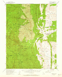
1952 Map of Paskenta
USGS Topo · Published 1962About this map
Mendocino National Forest dominates the western half of this landscape, where high peaks like Eagle Peak and Red Mtn give way to a network of creeks draining into the Sacramento Valley. The transition from the rugged Raglin Ridge to the eastern plains reveals a mid-century rural economy defined by family ranching and agriculture. Named homesteads and operations such as Scribner Ranch, Conklin Orchard, and the Finnell Ranch are scattered along the foothills, illustrating the settlement pattern of the period.
Find a feature on this map
82 named features on this map. Tap any name to fly to it.
Don’t see what you’re looking for? This feature index may not catch every label — zoom into the map to look around manually.
Map Details
Editions of this 1952 Paskenta Map
3 editions found
Other maps of this area

1890 · Red Bluff
USGS Topo · 1:250,000

1894 · Red Bluff
USGS Topo · 1:250,000

1919 · Fruto
USGS Topo · 1:62,500

1919 · Elk Creek
USGS Topo · 1:62,500

1944 · Fruto
USGS Topo · 1:62,500

1944 · Flournoy
USGS Topo · 1:62,500

1948 · Elk Creek
USGS Topo · 1:62,500

1949 · Colyear Springs
USGS Topo · 1:62,500

1952 · Red Bank
USGS Topo · 1:24,000

1952 · Paskenta
USGS Topo · 1:62,500