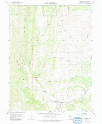
1967 Map of Paskenta
USGS Topo · Published 1985About this map
Paskenta serves as the focal point of this Northern California landscape, situated near the confluence of Thomes Creek and several minor tributaries. The town is marked by local infrastructure including an Athletic Field, Gaging Station, and the Paskenta Cemetery to the east. To the north and west, the terrain rises into a series of canyons and ridges, most notably High Flat Ridge and Cat Ridge, which are bisected by numerous seasonal and perennial watercourses like Elder Creek and Mill Creek.
Find a feature on this map
38 named features on this map. Tap any name to fly to it.
Don’t see what you’re looking for? This feature index may not catch every label — zoom into the map to look around manually.
Map Details
Editions of this 1967 Paskenta Map
2 editions found
Other maps of this area

1890 · Red Bluff
USGS Topo · 1:250,000

1894 · Red Bluff
USGS Topo · 1:250,000

1944 · Flournoy
USGS Topo · 1:62,500

1949 · Colyear Springs
USGS Topo · 1:62,500

1952 · Red Bank
USGS Topo · 1:24,000

1952 · Paskenta
USGS Topo · 1:62,500

1952 · Red Bank
USGS Topo · 1:62,500

1957 · Colyear Springs
USGS Topo · 1:62,500

1957 · Ukiah
USGS Topo · 1:250,000

1958 · Redding
USGS Topo · 1:250,000