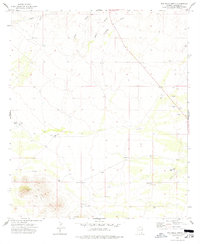
1974 Map of Pat Hills North
USGS Topo · Published 1977About this map
The high desert landscape of Cochise County is defined by the Pat Hills and their prominent high point, Landmark. This mid-1970s survey reveals an arid environment where water management was central to survival and ranching, evidenced by scattered infrastructure like Shaw Well 3, Deep Well, and several Water Tanks. The drainage patterns of Cienega Draw, Ideal Draw, and Mogul Draw run across the northern sections, while Pinery Creek cuts through the southeastern corner. Evidence of human activity and ranching commerce is found at the Creasey Ranch and various livestock enclosures simply marked as Corral and Corrals. Transportation in this era relied on a network of rough routes including a primary Jeep Trail, while the presence of several Gravel Pits and various Prospects indicates localized mineral interest and road-building activity during this period of Arizona's development.
Find a feature on this map
19 named features on this map. Tap any name to fly to it.
Don’t see what you’re looking for? This feature index may not catch every label — zoom into the map to look around manually.
Map Details
Editions of this 1974 Pat Hills North Map
This is the sole edition of this map. No revisions or reprints were ever made.
Other maps of this area

1916 · Pearce
USGS Topo · 1:125,000

1917 · San Simon
USGS Topo · 1:125,000

1917 · Chiricahua
USGS Topo · 1:125,000

1919 · Chiricahua
USGS Topo · 1:125,000

1922 · Willcox
USGS Topo · 1:125,000

1926 · Light
USGS Topo · 1:62,500

1926 · Cochise Head
USGS Topo · 1:62,500

1926 · Rucker
USGS Topo · 1:62,500

1943 · Dos Cabezas
USGS Topo · 1:62,500

1950 · Cochise Head
USGS Topo · 1:62,500