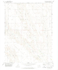
1978 Map of Peace Valley
USGS Topo · Published 1978About this map
Kirkland Cem provides a focal point for genealogical research in this rural portion of Lincoln County, situated near the headwaters of Dead Horse Creek. The landscape is defined by the broad drainage systems of Peace Valley and the expansive Ninemile Flats, where seasonal water sources like Pats Draw and various unnamed Springs dictate the placement of ranching infrastructure. Isolated landmarks such as the Andy Windmill and several water Tank sites emphasize the importance of groundwater in this high plains environment during the late 1970s.
Find a feature on this map
16 named features on this map. Tap any name to fly to it.
Don’t see what you’re looking for? This feature index may not catch every label — zoom into the map to look around manually.
Map Details
Editions of this 1978 Peace Valley Map
This is the sole edition of this map. No revisions or reprints were ever made.
Other maps of this area

1889 · Sanborn
USGS Topo · 1:125,000

1891 · Sanborn
USGS Topo · 1:125,000

1893 · Sanborn
USGS Topo · 1:125,000

1954 · Lamar
USGS Topo · 1:250,000

1958 · Lamar
USGS Topo · 1:250,000

1977 · Walker Point
USGS Topo · 1:24,000

1977 · Punkin Center
USGS Topo · 1:24,000
1978 · Cockleburr Springs
USGS Topo · 1:24,000
1978 · Sanborn Reservoir
USGS Topo · 1:24,000
1978 · Kutch SW
USGS Topo · 1:24,000