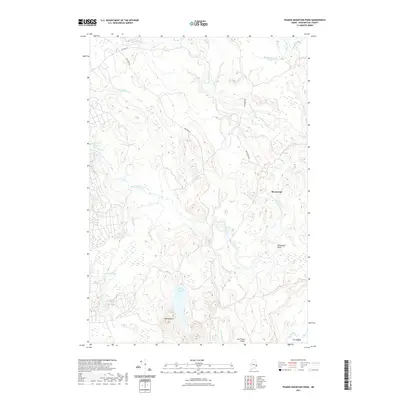
2021 Map of Peaked Mountain Pond
USGS Topo · Published 2021About this map
Machias River and its intricate tributaries dominate this Washington County landscape, revealing a region defined by water and woods. The river's path is marked by distinctive hydrological features such as Holmes Falls and the series of Lower Wigwam Rapids and Upper Wigwam Rapids. To the south, Peaked Mountain Pond sits at the base of Peaked Mtn, while the Chandler River carves a sharp turn known as The Oxbow in the southeast. A small cluster of activity is indicated at Rivers End, where various brooks like Soddy Meadow Brook and Palmer Brook converge toward the main river channel. The topography here, from Jim Wood Ridge to the low-lying Grassy Pond, suggests a wilderness primarily accessed by logging roads like Bear Brk Rd and Guptill Rd.
Find a feature on this map
27 named features on this map. Tap any name to fly to it.
Don’t see what you’re looking for? This feature index may not catch every label — zoom into the map to look around manually.
Map Details
Editions of this 2021 Peaked Mountain Pond Map
This is the sole edition of this map. No revisions or reprints were ever made.
Other maps of this area

1902 · Cherryfield
USGS Topo · 1:62,500

1904 · Cherryfield
USGS Topo · 1:62,500

1921 · Columbia Falls
USGS Topo · 1:62,500

1921 · Columbia Falls
USGS Topo · 1:62,500

1941 · Columbia Falls
USGS Topo · 1:62,500

1941 · Wesley
USGS Topo · 1:62,500

1941 · Tug Mountain
USGS Topo · 1:62,500

1942 · Cherryfield
USGS Topo · 1:62,500

1942 · Columbia Falls
USGS Topo · 1:62,500

1943 · Tug Mountain
USGS Topo · 1:62,500