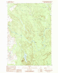
1990 Map of Peaked Mountain Pond
USGS Topo · Published 1990About this map
Machias River dominates this landscape, winding through a network of unorganized territories and small townships in Washington County. The waterway is punctuated by features like Holmes Falls and Lower Wigwam Rapids, while the surrounding terrain is defined by the elevation of Peaked Mountain and the expansive Sam Hill Barrens. Human presence is sparse, marked primarily by isolated points like Mattimo Place and Rivers End, suggesting a region focused on timber, traditional river navigation, and outdoor activity.
Find a feature on this map
32 named features on this map. Tap any name to fly to it.
Don’t see what you’re looking for? This feature index may not catch every label — zoom into the map to look around manually.
Map Details
Editions of this 1990 Peaked Mountain Pond Map
This is the sole edition of this map. No revisions or reprints were ever made.
Other maps of this area

1902 · Cherryfield
USGS Topo · 1:62,500

1904 · Cherryfield
USGS Topo · 1:62,500

1921 · Columbia Falls
USGS Topo · 1:62,500

1921 · Columbia Falls
USGS Topo · 1:62,500

1941 · Columbia Falls
USGS Topo · 1:62,500

1941 · Wesley
USGS Topo · 1:62,500

1941 · Tug Mountain
USGS Topo · 1:62,500

1942 · Cherryfield
USGS Topo · 1:62,500

1942 · Columbia Falls
USGS Topo · 1:62,500

1943 · Tug Mountain
USGS Topo · 1:62,500