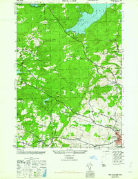
1962 Map of Peck Lake
USGS Topo · Published 1962About this map
Adirondack State Park covers the northern reaches of this mid-century survey, where Peck Lake and East Caroga Lake dominate the wooded landscape of Fulton County. The southern half of the sheet reveals a dense network of early rural settlements and school districts, illustrating the established social geography of the era. Places like North Bush, Meco, and Kecks Center are documented alongside numerous family-named burial grounds including McBeth Cem and Rhodes Cem. The map captures the transition from the wilder uplands near Bleecker and Caroga to the more developed township of Johnstown. Notable infrastructure for the time includes the Canajoharie Reservoir and the Johnstown Reservoir, while local educational history is preserved through the locations of the Peck Lake School, Wemple Sch, and Clip Hill Sch.
Find a feature on this map
48 named features on this map. Tap any name to fly to it.
Don’t see what you’re looking for? This feature index may not catch every label — zoom into the map to look around manually.
Map Details
Editions of this 1962 Peck Lake Map
This is the sole edition of this map. No revisions or reprints were ever made.
Other maps of this area

1896 · Fonda
USGS Topo · 1:62,500

1898 · Fonda
USGS Topo · 1:62,500

1898 · Canajoharie
USGS Topo · 1:62,500

1900 · Canajoharie
USGS Topo · 1:62,500

1901 · Lassellsville
USGS Topo · 1:62,500

1902 · Canajoharie
USGS Topo · 1:62,500

1902 · Fonda
USGS Topo · 1:62,500

1903 · Gloversville
USGS Topo · 1:62,500

1903 · Lassellsville
USGS Topo · 1:62,500

1943 · Gloversville
USGS Topo · 1:62,500