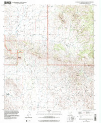
1996 Map of Pedregosa Mountains West
USGS Topo · Published 2003About this map
Coronado National Forest and the Leslie Canyon National Wildlife Refuge anchor this corner of Cochise County, where the high-elevation terrain of the Pedregosa Mountains meets the desert floor. The landscape is defined by its drainage patterns and verticality, from the prominent Packsaddle Mountain and Castle Dome to the winding depths of Tom Ketchum Canyon and Lonesome Canyon. Evidence of human industry and resource extraction is scattered throughout the southern reaches of the range, marked by several Mine Shafts, a Prospect, and Quarries near Deep Canyon. This arid environment relied heavily on seasonal water sources and intermittent flows, indicated by the presence of Walnut Spring, Mud Springs Draw, and the broad Poverty Flat. The network of 4wd tracks suggests a region utilized for ranching, mining, and conservation, maintaining its primitive character late into the twentieth century.
Find a feature on this map
24 named features on this map. Tap any name to fly to it.
Don’t see what you’re looking for? This feature index may not catch every label — zoom into the map to look around manually.
Map Details
Editions of this 1996 Pedregosa Mountains West Map
This is the sole edition of this map. No revisions or reprints were ever made.
Other maps of this area

1914 · Douglas
USGS Topo · 1:62,500

1916 · Pearce
USGS Topo · 1:125,000

1916 · Douglas
USGS Topo · 1:125,000

1917 · Chiricahua
USGS Topo · 1:125,000

1919 · Douglas
USGS Topo · 1:125,000

1919 · Perilla
USGS Topo · 1:125,000

1919 · Chiricahua
USGS Topo · 1:125,000

1922 · Swisshelm
USGS Topo · 1:62,500

1925 · Douglas
USGS Topo · 1:62,500

1926 · Pedregosa
USGS Topo · 1:62,500