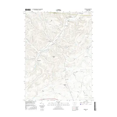
2016 Map of Penfield
USGS Topo · Published 2016About this map
Penfield and the surrounding coal-country settlements of Clearfield and Elk counties are defined by a complex network of narrow valleys and high ridges. The landscape is deeply carved by water, with Bennett Br Sinnemahoning Cr and its many tributaries, such as Wilson Run and Laurel Run, creating the corrugated terrain of Horning Hollow and Matley Hollow. Local landmarks like Gobbler Knob and The Hogback rise above the drainage basins of Anderson Cr and Bark Camp Run. Genealogists and local historians will find several burial sites preserved on these slopes, including Mount Pleasant Cem near the Elk County line and Bundy Cem near Winterburn. The presence of small hamlets like Scattertown, Hollywood, and Tyler alongside infrastructure such as the Penfield Reservoir illustrates the historical reliance on these mountain hollows for both settlement and water resources.
Find a feature on this map
86 named features on this map. Tap any name to fly to it.
Don’t see what you’re looking for? This feature index may not catch every label — zoom into the map to look around manually.
Map Details
Editions of this 2016 Penfield Map
This is the sole edition of this map. No revisions or reprints were ever made.
Other maps of this area

1929 · Clearfield
USGS Topo · 1:48,000

1929 · Penfield
USGS Topo · 1:62,500

1932 · Clearfield
USGS Topo · 1:62,500

1932 · Penfield
USGS Topo · 1:62,500

1941 · Benezette
USGS Topo · 1:62,500

1941 · Ridgway
USGS Topo · 1:62,500

1943 · Benezette
USGS Topo · 1:62,500

1944 · Ridgway
USGS Topo · 1:62,500

1957 · Warren
USGS Topo · 1:250,000

1958 · Warren
USGS Topo · 1:250,000
Featured Places
- Tyler, Huston Township
- Hoovertown, Huston Township
- Jay Township, PA
- Penfield, Huston Township
- Winterburn, Huston Township