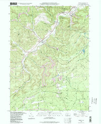
1993 Map of Penfield
USGS Topo · Published 1998About this map
Penfield sits at the heart of this landscape where the Penn Central rail line follows the valley of the Bennett Branch. This late-century update documents a region defined by its timber and mineral heritage, situated largely within the Moshanon State Forest and Elk State Forest. Small settlements like Hollywood and Winterburn are linked by a network of forest roads and grades, including the Weiss Grade, reflecting a history of industrial access to these deep hollows.
Find a feature on this map
55 named features on this map. Tap any name to fly to it.
Don’t see what you’re looking for? This feature index may not catch every label — zoom into the map to look around manually.
Map Details
Editions of this 1993 Penfield Map
This is the sole edition of this map. No revisions or reprints were ever made.
Other maps of this area

1929 · Clearfield
USGS Topo · 1:48,000

1929 · Penfield
USGS Topo · 1:62,500

1932 · Clearfield
USGS Topo · 1:62,500

1932 · Penfield
USGS Topo · 1:62,500

1941 · Benezette
USGS Topo · 1:62,500

1941 · Ridgway
USGS Topo · 1:62,500

1943 · Benezette
USGS Topo · 1:62,500

1944 · Ridgway
USGS Topo · 1:62,500

1957 · Warren
USGS Topo · 1:250,000

1958 · Warren
USGS Topo · 1:250,000
Featured Places
- Pine Township, PA
- Gobbler Knob, Huston Township
- Fox Township, PA
- Penfield, Huston Township
- Anderson Creek, Pine Township