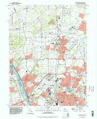
1995 Map of Pennington
USGS Topo · Published 1998About this map
Washington Crossing serves as a historic focal point where the Delaware River separates New Jersey from Pennsylvania, accompanied by the preserved grounds of Washington Crossing State Park. The landscape transition from the heights of Baldpate Mountain and Pennington Mountain down toward the suburbanizing corridor of Ewing reflects the post-war growth of Mercer County. Significant institutional presence is visible through the New Jersey State Teachers College, the U S Naval Reservation, and the State School For Deaf. Transportation routes are defined by historic river crossings like Scudders Falls and the engineered path of the Delaware and Raritan Canal. Smaller crossroads such as Bear Tavern, Harbourton, and Marshalls Corner maintain their identities amidst a network of brooks including Stony Brook and Jacobs Creek.
Find a feature on this map
88 named features on this map. Tap any name to fly to it.
Don’t see what you’re looking for? This feature index may not catch every label — zoom into the map to look around manually.
Map Details
Editions of this 1995 Pennington Map
This is the sole edition of this map. No revisions or reprints were ever made.
Other maps of this area

1888 · Bordentown
USGS Topo · 1:62,500

1888 · Princeton
USGS Topo · 1:62,500

1890 · Lambertville
USGS Topo · 1:62,500

1890 · Burlington
USGS Topo · 1:62,500

1891 · Lambertville
USGS Topo · 1:62,500

1893 · Bordentown
USGS Topo · 1:62,500

1893 · Burlington
USGS Topo · 1:62,500

1894 · Princeton
USGS Topo · 1:62,500

1894 · Lambertville
USGS Topo · 1:62,500

1904 · Burlington
USGS Topo · 1:62,500
Featured Places
- Ewing Township, NJ
- Lawrence Township, NJ
- Lower Makefield Township, PA
- Hopewell Township, NJ
- Upper Makefield Township, PA