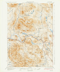
1934 Map of Percy
USGS Topo · Published 1934About this map
Stark and Milan are central to this 1930s survey of Coos County, where the Ammonoosuc River and the Grand Trunk railroad carve a vital transit corridor through the White Mountain National Forest. The map documents a landscape defined by sharp peaks like the Percy Peaks and Hutchins Mtn, interspersed with rural social hubs such as the Emerson Sch and the Dummer Plain Sch.
Find a feature on this map
93 named features on this map. Tap any name to fly to it.
Don’t see what you’re looking for? This feature index may not catch every label — zoom into the map to look around manually.
Map Details
Editions of this 1934 Percy Map
3 editions found

Other maps of this area

1893 · Mt. Washington
USGS Topo · 1:62,500

1893 · Gorham
USGS Topo · 1:62,500

1896 · Mt. Washington
USGS Topo · 1:62,500

1896 · Gorham
USGS Topo · 1:62,500

1900 · Whitefield
USGS Topo · 1:62,500

1920 · Guildhall
USGS Topo · 1:62,500

1929 · Averill
USGS Topo · 1:62,500

1930 · Milan
USGS Topo · 1:62,500

1930 · Percy
USGS Topo · 1:62,500

1930 · Dixville
USGS Topo · 1:62,500