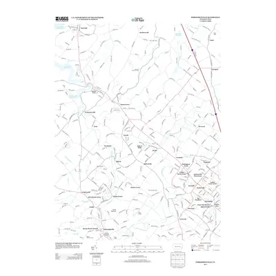
2013 Map of Perkiomenville
USGS Topo · Published 2013About this map
Perkiomen Creek and its East Branch define the landscape of this Montgomery County region, where traditional rural hamlets and contemporary residential developments coexist. The lower portion of the map is anchored by the historic Spring Mount Summit and the nearby Governor Pennypacker Monument, reflecting the area's significance in Pennsylvania's political and recreational history. To the north, the massive Green Lane Reservoir and Maple Run Reservoir dominate the topography, surrounded by organized youth camps such as Hart Scout Camp and Delmont Boy Scout Camp. The transition from agrarian roots to suburban clusters is evident in the proximity of Indian Crest Farms to residential enclaves like Bellingham Knoll and The Heathers. A unique aviation pattern also emerges, with Shontz Airport, Kings Airport, and Yarrow Airport all situated within this relatively compact corridor.
Find a feature on this map
292 named features on this map. Tap any name to fly to it.
Don’t see what you’re looking for? This feature index may not catch every label — zoom into the map to look around manually.
Map Details
Editions of this 2013 Perkiomenville Map
This is the sole edition of this map. No revisions or reprints were ever made.
Other maps of this area

1888 · Quakertown
USGS Topo · 1:62,500

1890 · Quakertown
USGS Topo · 1:62,500

1894 · Quakertown
USGS Topo · 1:62,500

1894 · Norristown
USGS Topo · 1:62,500

1895 · Norristown
USGS Topo · 1:62,500

1896 · Norristown
USGS Topo · 1:62,500

1902 · Boyertown
USGS Topo · 1:62,500

1906 · Phoenixville
USGS Topo · 1:62,500

1942 · Norristown
USGS Topo · 1:125,000
1943 · Quakertown
USGS Topo · 1:31,680
Featured Places
- Limerick Township, PA
- Skippack Township, PA
- Franconia Township, PA
- Harleysville, Lower Salford Township
- New Hanover Township, PA