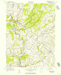
1953 Map of Perkiomenville
USGS Topo · Published 1954About this map
Perkiomen Creek defines the local landscape of northern Montgomery County in the early 1950s, its winding path punctuated by several small villages and the steel tracks of the Reading Railroad. This map illustrates a transition between established agricultural hamlets and early modern infrastructure, featuring notable landmarks like the Eastern Bible Institute and the historic Old Goshenhoppen Ch. Small crossroads and rail stops, such as Hendricks and McLeans Station, show the enduring pattern of 19th-century settlement still intact before the suburban growth of later decades.
Find a feature on this map
64 named features on this map. Tap any name to fly to it.
Don’t see what you’re looking for? This feature index may not catch every label — zoom into the map to look around manually.
Map Details
Editions of this 1953 Perkiomenville Map
2 editions found
Other maps of this area

1888 · Quakertown
USGS Topo · 1:62,500

1890 · Quakertown
USGS Topo · 1:62,500

1894 · Quakertown
USGS Topo · 1:62,500

1894 · Norristown
USGS Topo · 1:62,500

1895 · Norristown
USGS Topo · 1:62,500

1896 · Norristown
USGS Topo · 1:62,500

1902 · Boyertown
USGS Topo · 1:62,500

1906 · Phoenixville
USGS Topo · 1:62,500

1942 · Norristown
USGS Topo · 1:125,000
1943 · Quakertown
USGS Topo · 1:31,680
Featured Places
- Limerick Township, PA
- Skippack Township, PA
- Franconia Township, PA
- Harleysville, Lower Salford Township
- New Hanover Township, PA