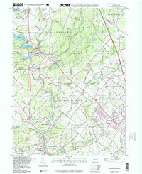
1997 Map of Perkiomenville
USGS Topo · Published 1999About this map
Green Lane Reservoir and the winding course of Perkiomen Creek dominate the landscape of northwestern Montgomery County in this late 20th-century survey. The area maintains a distinct rural character, centered around long-standing crossroads settlements such as Sumneytown, Perkiomenville, and Harleysville. This map captures a significant concentration of communal history, from the historic Old Goshenhoppen Ch to the Tabor Cem Ch, reflecting the deep roots of the region’s early German congregations. The landscape is also shaped by expansive public lands, including the Upper Perkiomen Valley County Park and the grounds of Pennypacker Mills County Park. While the Northeast Extension Pennsylvania Turnpike cuts through the eastern portion, the interior remains a network of country roads, creek-side quarries, and small rural schools like the Salford-Upper Salford Township Sch.
Find a feature on this map
73 named features on this map. Tap any name to fly to it.
Don’t see what you’re looking for? This feature index may not catch every label — zoom into the map to look around manually.
Map Details
Editions of this 1997 Perkiomenville Map
This is the sole edition of this map. No revisions or reprints were ever made.
Other maps of this area

1888 · Quakertown
USGS Topo · 1:62,500

1890 · Quakertown
USGS Topo · 1:62,500

1894 · Quakertown
USGS Topo · 1:62,500

1894 · Norristown
USGS Topo · 1:62,500

1895 · Norristown
USGS Topo · 1:62,500

1896 · Norristown
USGS Topo · 1:62,500

1902 · Boyertown
USGS Topo · 1:62,500

1906 · Phoenixville
USGS Topo · 1:62,500

1942 · Norristown
USGS Topo · 1:125,000
1943 · Quakertown
USGS Topo · 1:31,680
Featured Places
- Limerick Township, PA
- Skippack Township, PA
- Franconia Township, PA
- Harleysville, Lower Salford Township
- New Hanover Township, PA