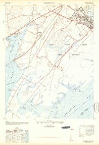
1949 Map of Perryman
USGS Topo · Published 1949About this map
The Aberdeen Proving Ground Military Reservation dominates the eastern half of this Harford County landscape, illustrating the significant military footprint along the Chesapeake Bay during the post-war period. The map details the technical infrastructure of the era, from the Phillips Field landing strips and control tower to specialized firing ranges such as the Pistol Range and Rifle Range. Away from the military installations, the community of Perryman and the industrial activity near Belcamp are served by a dense network of transport, including the Baltimore and Ohio Railroad and the Pennsylvania Railroad. Local heritage is well-preserved through labels for the Harford Furnace School, Spesutie Church, and the site of Old Baltimore near the mouth of the Romney Creek. The complex shoreline, marked by Poverty Island Area and various points like Chilbury Point, showcases the interface of tidal guts and rural farmland typical of the upper bay.
Find a feature on this map
66 named features on this map. Tap any name to fly to it.
Don’t see what you’re looking for? This feature index may not catch every label — zoom into the map to look around manually.
Map Details
Editions of this 1949 Perryman Map
This is the sole edition of this map. No revisions or reprints were ever made.
Other maps of this area

1893 · Gunpowder
USGS Topo · 1:62,500

1898 · Tolchester
USGS Topo · 1:125,000

1900 · Havre De Grace
USGS Topo · 1:62,500

1900 · Betterton
USGS Topo · 1:62,500

1901 · Belair
USGS Topo · 1:62,500

1901 · Gunpowder
USGS Topo · 1:62,500

1903 · Tolchester
USGS Topo · 1:125,000

1908 · Tolchester
USGS Topo · 1:125,000

1941 · Gunpowder
USGS Topo · 1:62,500

1942 · Havre De Grace
USGS Topo · 1:62,500