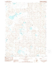
1989 Map of Peter Long Lake
USGS Topo · Published 1989About this map
Peter Long Lake and a series of wind-carved depressions define this pocket of the Nebraska Sandhills in Sheridan County. The landscape is characterized by its internal drainage and numerous alkaline or freshwater lakes, including Potmesil Lake and Snow Lake, which sit amidst undulating sand dunes. Ranching is the primary footprint of human activity, represented by scattered homesteads and headquarters such as Joy Ranch in the north and the Panhandle Ranch near the center of the quadrangle. These operations are connected by a network of 4 WD trails, reflecting the isolation and specialized land use of the region during the late 1980s. The naming of smaller bodies of water like Nye Lake and Conley Lake suggests the importance of these water sources to local families and livestock in an otherwise arid grazing environment.
Find a feature on this map
17 named features on this map. Tap any name to fly to it.
Don’t see what you’re looking for? This feature index may not catch every label — zoom into the map to look around manually.
Map Details
Editions of this 1989 Peter Long Lake Map
This is the sole edition of this map. No revisions or reprints were ever made.
Other maps of this area

1948 · Antioch
USGS Topo · 1:62,500

1948 · Lakeside
USGS Topo · 1:62,500

1948 · Twin Lakes
USGS Topo · 1:62,500

1949 · Antioch
USGS Topo · 1:62,500

1950 · Twin Lakes
USGS Topo · 1:62,500

1950 · Lakeside
USGS Topo · 1:62,500

1950 · Skunk Lake
USGS Topo · 1:62,500

1955 · Alliance
USGS Topo · 1:250,000

1957 · Alliance
USGS Topo · 1:250,000

1958 · Alliance
USGS Topo · 1:250,000