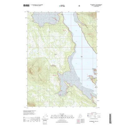
2017 Map of Petersburg C-4 NW
USGS Topo · Published 2017About this map
Kupreanof Island dominates this southeastern Alaskan landscape, characterized by dense wetlands and complex coastal waterways within the Tongass National Forest. The map detail follows the southeastern shore of the island, where Indian Point and Rookery Island define the transition from forest to tidal waters. Toward the south, the archipelago fragments into smaller landforms including Big Castle Island and High Castle Island, situated near the mouth of the Castle River.
Find a feature on this map
17 named features on this map. Tap any name to fly to it.
Don’t see what you’re looking for? This feature index may not catch every label — zoom into the map to look around manually.
Map Details
Editions of this 2017 Petersburg C-4 NW Map
This is the sole edition of this map. No revisions or reprints were ever made.
Other maps of this area

1948 · Petersburg C-4
USGS Topo · 1:63,360

1948 · Petersburg C-5
USGS Topo · 1:63,360

1948 · Petersburg D-5
USGS Topo · 1:63,360

1951 · Petersburg D-4
USGS Topo · 1:63,360

1951 · Petersburg C-4
USGS Topo · 1:63,360

1951 · Petersburg C-5
USGS Topo · 1:63,360

1952 · Petersburg
USGS Topo · 1:250,000

1960 · Petersburg
USGS Topo · 1:250,000
1992 · Petersburg D-4 SE
USGS Topo · 1:25,000
1995 · Petersburg C-4
USGS Topo · 1:63,360