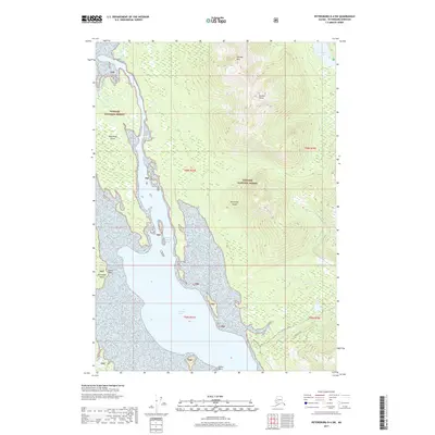
2017 Map of Petersburg D-4 SW
USGS Topo · Published 2017About this map
Kupreanof Island dominates this coastal landscape, where the tidal waters of Duncan Canal cut deep into the timbered interior of the Tongass National Forest. The map documents a rugged wilderness setting defined by sharp elevation changes, rising from the shoreline at Goose Point to the high summits of Portage Mtn and Duncan Peaks. Significant for its depiction of local transport and infrastructure, the sheet tracks the White Alice and Mitchell-Tonka routes through the southern terrain, providing essential context for the region's mid-century communication and logging history. Smaller hydrological features like Petersburg Lake and the winding Duncan Cr illustrate the drainage patterns that have shaped the island's geography, while coastal markers such as Indian Point and Copper Slough serve as critical reference points for navigation and local history.
Find a feature on this map
17 named features on this map. Tap any name to fly to it.
Don’t see what you’re looking for? This feature index may not catch every label — zoom into the map to look around manually.
Map Details
Editions of this 2017 Petersburg D-4 SW Map
This is the sole edition of this map. No revisions or reprints were ever made.
Other maps of this area

1948 · Petersburg C-4
USGS Topo · 1:63,360

1948 · Petersburg C-5
USGS Topo · 1:63,360

1948 · Petersburg D-5
USGS Topo · 1:63,360

1951 · Petersburg D-4
USGS Topo · 1:63,360

1951 · Petersburg C-4
USGS Topo · 1:63,360

1951 · Petersburg C-5
USGS Topo · 1:63,360

1952 · Petersburg
USGS Topo · 1:250,000

1960 · Petersburg
USGS Topo · 1:250,000
1992 · Petersburg D-4 SE
USGS Topo · 1:25,000
1995 · Petersburg C-4
USGS Topo · 1:63,360