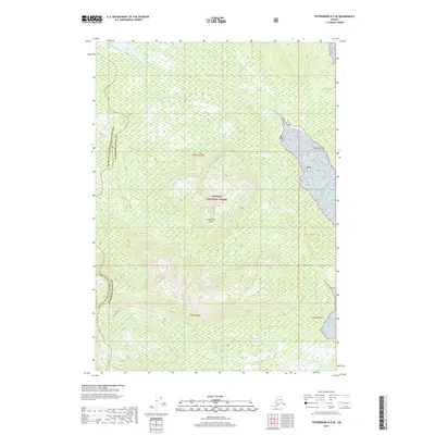
2017 Map of Petersburg D-5 SE
USGS Topo · Published 2017About this map
Kupreanof Island defines the heart of this coastal wilderness within the Tongass National Forest. The landscape is dominated by high-elevation terrain and dense forest, where drainage systems like Taylor Cr and the northern Towers Lake carve through the island's interior. This 2017 survey reflects a largely untouched environment where modern administrative lines meet ancient geography. The map documents the border between the Petersburg Borough and the Prince of Wales-Hyder Census Area, showing how these political boundaries follow the natural topography of the island. For researchers or outdoorsmen, the sheet provides exact coordinates for the township and range grids, including t58s r76e and t59s r76e, which organize this vast Alaskan temperate rainforest.
Find a feature on this map
9 named features on this map. Tap any name to fly to it.
Don’t see what you’re looking for? This feature index may not catch every label — zoom into the map to look around manually.
Map Details
Editions of this 2017 Petersburg D-5 SE Map
This is the sole edition of this map. No revisions or reprints were ever made.
Other maps of this area

1948 · Petersburg C-4
USGS Topo · 1:63,360

1948 · Petersburg C-5
USGS Topo · 1:63,360

1948 · Petersburg D-5
USGS Topo · 1:63,360

1951 · Petersburg D-4
USGS Topo · 1:63,360

1951 · Petersburg C-4
USGS Topo · 1:63,360

1951 · Petersburg C-5
USGS Topo · 1:63,360

1952 · Petersburg
USGS Topo · 1:250,000

1960 · Petersburg
USGS Topo · 1:250,000
1995 · Petersburg C-4
USGS Topo · 1:63,360
1995 · Petersburg D-4
USGS Topo · 1:63,360