
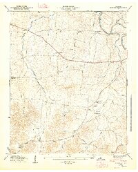
1936 Map of Petersburg
USGS Topo · Published 1936About this map
Petersburg anchors this 1936 survey, which sits at the intersection of the Nashville Chattanooga and St Louis Railway and State Highway No 50. The landscape is a network of small family farming communities and crossroads such as Delina, Talley, and Blakeville. Cultural life in the mid-1930s is mapped through numerous rural institutions, including Haislip Sch, Union Sch, and churches like Catalpa Grove Ch and Mt Zion Ch. The drainage patterns of Cane Creek and its many branches, such as Gould Branch and Albright Branch, dictated the placement of early homesteads and cemeteries. Genealogists can find several family-named landmarks, including the Talley Cem, Welch Cem, and Pigg Cem. This Tennessee Valley Authority collaboration highlights the rural infrastructure before significant mid-century modernization, preserving the locations of sites like Browns Shop and Bryant Spring.
Find a feature on this map
71 named features on this map. Tap any name to fly to it.
Don’t see what you’re looking for? This feature index may not catch every label — zoom into the map to look around manually.
Map Details
Editions of this 1936 Petersburg Map
This is the sole edition of this map. No revisions or reprints were ever made.
Other maps of this area

1936 · Belfast
USGS Topo · 1:24,000

1936 · Cornersville
USGS Topo · 1:24,000

1936 · Lewisburg
USGS Topo · 1:24,000

1936 · Belleville
USGS Topo · 1:24,000

1936 · Boonshill
USGS Topo · 1:24,000

1936 · Bedford
USGS Topo · 1:24,000

1936 · Frankewing
USGS Topo · 1:24,000

1936 · Fayetteville
USGS Topo · 1:24,000

1944 · Shelbyville
USGS Topo · 1:100,000
1947 · Bedford
USGS Topo · 1:24,000