
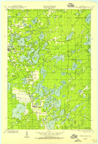
1950 Map of Phelps
USGS Topo · Published 1950About this map
Lac Vieux Desert straddles the border between Wisconsin and Michigan, anchoring a landscape defined by an intricate network of glacial lakes and northern forests. In the mid-20th century, the community of Phelps sits at the eastern edge of North Twin Lake, serving as a hub for local infrastructure including a Museum, a school, and the nearby Military Hill Fire Tower. The region is deeply integrated into the Nicolet National Forest, where the presence of a C C C Camp and Camp 2 reflect the era's focus on forest management and conservation.
Find a feature on this map
48 named features on this map. Tap any name to fly to it.
Don’t see what you’re looking for? This feature index may not catch every label — zoom into the map to look around manually.
Map Details
Editions of this 1950 Phelps Map
This is the sole edition of this map. No revisions or reprints were ever made.
Other maps of this area

1928 · Three Lakes
USGS Topo · 1:48,000

1930 · Robbins
USGS Topo · 1:48,000

1938 · Phelps
USGS Topo · 1:48,000

1938 · Alvin
USGS Topo · 1:48,000
1938 · Three Lakes
USGS Topo · 1:48,000
1938 · Robbins
USGS Topo · 1:48,000

1945 · Three Lakes
USGS Topo · 1:48,000

1945 · Robbins
USGS Topo · 1:48,000

1946 · Star Lake
USGS Topo · 1:48,000

1946 · Alvin
USGS Topo · 1:48,000