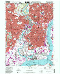
1995 Map of Philadelphia
USGS Topo · Published 1999About this map
Fairmount Park serves as a massive green anchor for this urban landscape, where the Schuylkill River snakes past iconic landmarks like the Museum of Art and Memorial Hall. The dense grid of the city center preserves significant heritage sites including Independence Hall and Independence National Historical Park, surrounded by a collection of historic neighborhood squares such as Rittenhouse Square and Washington Square. To the south, the industrial and military importance of the waterfront is evident in the sprawling U S Naval Shipyard and the U S Naval Station Mustin Field, while sports culture is marked by the presence of both Veterans Stadium and Kennedy Stadium. The map also details numerous religious and educational institutions, from St Josephs University in the north to parish schools like St Thomas Aquinas Sch, reflecting the deep-rooted community fabric of 20th-century Philadelphia.
Find a feature on this map
205 named features on this map. Tap any name to fly to it.
Don’t see what you’re looking for? This feature index may not catch every label — zoom into the map to look around manually.
Map Details
Editions of this 1995 Philadelphia Map
This is the sole edition of this map. No revisions or reprints were ever made.
Other maps of this area

1891 · Philadelphia
USGS Topo · 1:62,500

1893 · Germantown
USGS Topo · 1:62,500

1894 · Chester
USGS Topo · 1:62,500

1894 · Philadelphia
USGS Topo · 1:62,500

1894 · Norristown
USGS Topo · 1:62,500

1894 · Germantown
USGS Topo · 1:62,500

1895 · Norristown
USGS Topo · 1:62,500

1896 · Germantown
USGS Topo · 1:62,500

1896 · Philadelphia
USGS Topo · 1:62,500

1896 · Norristown
USGS Topo · 1:62,500