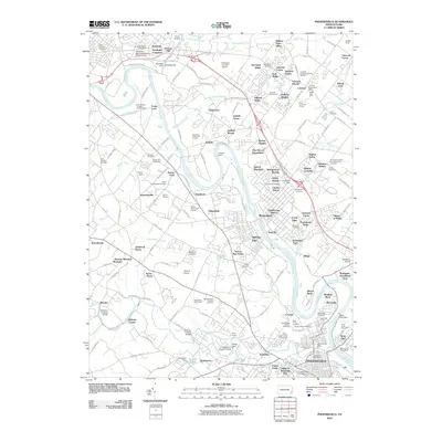
2010 Map of Phoenixville
USGS Topo · Published 2010About this map
The Schuylkill River carves a deep path through this industrial and suburban corridor, where historic crossings and modern infrastructure exist side-by-side. The massive Limerick Nuclear Pwr Plnt dominates the northern bend of the river, while traditional landmarks like Fricks Lock and Parkerford reveal the area’s older settlement patterns. Further south, the landscape is defined by the winding French Creek, which is home to several preservation-worthy structures including Sheeders Covered Bridge, Kennedy Covered Bridge, and the Rapps Dam Covered Bridge.
Find a feature on this map
198 named features on this map. Tap any name to fly to it.
Don’t see what you’re looking for? This feature index may not catch every label — zoom into the map to look around manually.
Map Details
Editions of this 2010 Phoenixville Map
This is the sole edition of this map. No revisions or reprints were ever made.
Other maps of this area

1888 · Quakertown
USGS Topo · 1:62,500

1890 · Quakertown
USGS Topo · 1:62,500

1894 · Quakertown
USGS Topo · 1:62,500

1894 · Norristown
USGS Topo · 1:62,500

1895 · Norristown
USGS Topo · 1:62,500

1896 · Norristown
USGS Topo · 1:62,500

1902 · Boyertown
USGS Topo · 1:62,500

1906 · Phoenixville
USGS Topo · 1:62,500

1942 · Norristown
USGS Topo · 1:125,000
1943 · Norristown
USGS Topo · 1:62,500