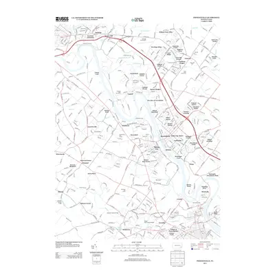
2013 Map of Phoenixville
USGS Topo · Published 2013About this map
The Schuylkill River carves a winding path through this portion of Montgomery County, anchoring a landscape where residential developments like Summer Chase and Ashford Green sit alongside enduring local landmarks. The area's heritage is preserved through several historic crossings, including the Rapps Dam Covered Bridge and Kennedy Covered Bridge over French Cr, as well as the Sheeders Covered Bridge. These structures contrast with the modern aviation activity at Heritage Field Airport and Lance Airport.
Find a feature on this map
408 named features on this map. Tap any name to fly to it.
Don’t see what you’re looking for? This feature index may not catch every label — zoom into the map to look around manually.
Map Details
Editions of this 2013 Phoenixville Map
This is the sole edition of this map. No revisions or reprints were ever made.
Other maps of this area

1888 · Quakertown
USGS Topo · 1:62,500

1890 · Quakertown
USGS Topo · 1:62,500

1894 · Quakertown
USGS Topo · 1:62,500

1894 · Norristown
USGS Topo · 1:62,500

1895 · Norristown
USGS Topo · 1:62,500

1896 · Norristown
USGS Topo · 1:62,500

1902 · Boyertown
USGS Topo · 1:62,500

1906 · Phoenixville
USGS Topo · 1:62,500

1942 · Norristown
USGS Topo · 1:125,000
1943 · Norristown
USGS Topo · 1:62,500