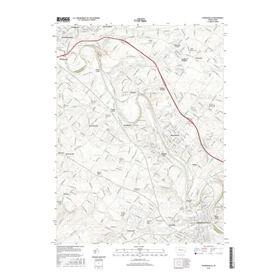
2016 Map of Phoenixville
USGS Topo · Published 2016About this map
The Schuylkill River carves a deep path through this Montgomery and Chester County landscape, serving as the historical spine for settlements from Pottstown down to Phoenixville. Traces of earlier transportation and industry remain visible, most notably the path of the Schuylkill Canal near Fricks Lock and the Black Rock Tunnel further downstream. The area preserves significant regional history through its varied burial grounds, including the Revolutionary Soldiers Cem and several denomination-specific sites like the Vincent Mennonite Cem and Parker Ford Baptist Cem. Rural heritage is further anchored by several traditional structures crossing French Creek, such as Sheeders Covered Bridge, Kennedy Covered Bridge, and Rapps Dam Covered Bridge. Small communities like Linfield, Royersford, and Spring City cluster near the river, reflecting the long-standing industrial and residential patterns of the Schuylkill valley.
Find a feature on this map
76 named features on this map. Tap any name to fly to it.
Don’t see what you’re looking for? This feature index may not catch every label — zoom into the map to look around manually.
Map Details
Editions of this 2016 Phoenixville Map
This is the sole edition of this map. No revisions or reprints were ever made.
Other maps of this area

1888 · Quakertown
USGS Topo · 1:62,500

1890 · Quakertown
USGS Topo · 1:62,500

1894 · Quakertown
USGS Topo · 1:62,500

1894 · Norristown
USGS Topo · 1:62,500

1895 · Norristown
USGS Topo · 1:62,500

1896 · Norristown
USGS Topo · 1:62,500

1902 · Boyertown
USGS Topo · 1:62,500

1906 · Phoenixville
USGS Topo · 1:62,500

1942 · Norristown
USGS Topo · 1:125,000
1943 · Norristown
USGS Topo · 1:62,500