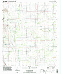
1996 Map of Picacho Pass
USGS Topo · Published 2003About this map
Picacho Pass serves as the focal point of this arid Pinal County landscape, where the Picacho Mountains rise abruptly from the desert floor. The 1996 data reveals a region defined by water management and resource extraction, notably the prominent Tucson Aqueduct and its associated flume cutting through the terrain. Evidence of historical and active desert utility is scattered throughout the quadrangle, from the Gold Bell Mine and various prospect sites to a network of desert wells including Clemens Well and the Barnett Well (Dry). The presence of a Landing Strip and a major Pipeline underscores the area's role as a transit corridor. Several ephemeral drainage systems like McClellan Wash and Durham Wash illustrate the natural hydrologic patterns that shaped the land long before modern infrastructure arrived.
Find a feature on this map
20 named features on this map. Tap any name to fly to it.
Don’t see what you’re looking for? This feature index may not catch every label — zoom into the map to look around manually.
Map Details
Editions of this 1996 Picacho Pass Map
This is the sole edition of this map. No revisions or reprints were ever made.
Other maps of this area

1922 · Red Rock No 2
USGS Topo · 1:48,000

1934 · Newman Peak
USGS Topo · 1:125,000

1947 · Red Rock
USGS Topo · 1:62,500

1956 · Tucson
USGS Topo · 1:250,000

1958 · Tucson
USGS Topo · 1:250,000

1959 · Tucson
USGS Topo · 1:250,000

1959 · Tortolita Mts
USGS Topo · 1:62,500

1962 · Tucson
USGS Topo · 1:250,000
1963 · Red Rock
USGS Topo · 1:62,500

1964 · Tucson
USGS Topo · 1:250,000