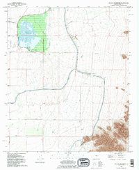
1992 Map of Picacho Reservoir
USGS Topo · Published 1995About this map
Picacho Reservoir serves as a central hydrological landmark in Pinal County, where its spillway elevation of 1505 feet dictates the local water management landscape. This 1990s-era mapping reveals a complex network of desert irrigation and water transport, dominated by the massive Tucson Aqueduct and the Florence Casa Grande Canal. The intricate layout of canals, including the Santa Rosa Canal and the Central Main Canal, illustrates the engineered efforts to redirect water across the arid basin. Infrastructure like the Brady Pumping Plant and the Picacho Pumping Plant support this system, while local transit is anchored by routes such as Selma Hwy and Hanna Rd. The presence of several Check Gates and a Gaging Station further emphasizes the controlled nature of the water flow through the Florence Casa Grande Canal Extension during this period.
Find a feature on this map
20 named features on this map. Tap any name to fly to it.
Don’t see what you’re looking for? This feature index may not catch every label — zoom into the map to look around manually.
Map Details
Editions of this 1992 Picacho Reservoir Map
This is the sole edition of this map. No revisions or reprints were ever made.
Other maps of this area

1922 · Red Rock No 2
USGS Topo · 1:48,000

1922 · Signal Peak
USGS Topo · 1:62,500

1924 · Signal Peak
USGS Topo · 1:62,500

1934 · Newman Peak
USGS Topo · 1:125,000

1947 · Red Rock
USGS Topo · 1:62,500

1947 · Eloy
USGS Topo · 1:62,500

1948 · Eloy
USGS Topo · 1:62,500

1956 · Tucson
USGS Topo · 1:250,000

1958 · Tucson
USGS Topo · 1:250,000

1959 · Tucson
USGS Topo · 1:250,000