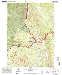
1997 Map of Pico Peak
USGS Topo · Published 2000About this map
Pico Peak and the surrounding high country of the Coolidge Range dominate this late-1990s landscape, serving as a hub for both wilderness preservation and winter recreation. The intersection of the Appalachian National Scenic Trail and the Long National Recreation Trail highlights the importance of this terrain to the regional hiking network, supported by landmarks like the Rolston Rest Shelter and Tucker Johnson Shelter.
Find a feature on this map
57 named features on this map. Tap any name to fly to it.
Don’t see what you’re looking for? This feature index may not catch every label — zoom into the map to look around manually.
Map Details
Editions of this 1997 Pico Peak Map
This is the sole edition of this map. No revisions or reprints were ever made.
Other maps of this area

1891 · Rutland
USGS Topo · 1:62,500

1893 · Rutland
USGS Topo · 1:62,500

1911 · Woodstock
USGS Topo · 1:62,500

1913 · Woodstock
USGS Topo · 1:62,500

1915 · Rochester
USGS Topo · 1:62,500

1917 · Rochester
USGS Topo · 1:62,500

1919 · Royalton
USGS Topo · 1:62,500

1924 · Randolph
USGS Topo · 1:48,000

1926 · Randolph
USGS Topo · 1:62,500

1943 · Woodstock
USGS Topo · 1:62,500