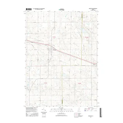
2016 Map of Pierceton
USGS Topo · Published 2016About this map
Pierceton and Larwill anchor this portrait of the Northern Indiana landscape along the boundary of Kosciusko Co and Whitley Co. The area is defined by a dense network of glacial lakes and drainage systems, including Pierceton Lake, Robinson Lake, and Tennant Lake. This hydrography is supported by an intricate series of man-made and natural waterways such as Leedy Ditch, Deeds Cr, and Tennant Ditch, reflecting the region's agricultural drainage history. Local family and religious heritage is preserved at Hillcrest Cem and Saint Francis Cem, which sit near the crossroads of E-Pierceton Rd. To the west, the small settlement of Wooster remains connected by a grid of numbered county roads like E Old Road 30, while the southern reaches near the Whitley County line feature the Richland Center Cem and more isolated water bodies like Compton Lake.
Find a feature on this map
95 named features on this map. Tap any name to fly to it.
Don’t see what you’re looking for? This feature index may not catch every label — zoom into the map to look around manually.
Map Details
Editions of this 2016 Pierceton Map
This is the sole edition of this map. No revisions or reprints were ever made.
Other maps of this area

1950 · Leesburg
USGS Topo · 1:24,000

1950 · Pierceton
USGS Topo · 1:24,000

1950 · North Webster
USGS Topo · 1:24,000

1951 · Ormas
USGS Topo · 1:24,000

1953 · Fort Wayne
USGS Topo · 1:250,000

1956 · Fort Wayne
USGS Topo · 1:250,000

1956 · Lorane
USGS Topo · 1:24,000

1957 · Warsaw
USGS Topo · 1:24,000
1962 · North Manchester North
USGS Topo · 1:24,000
1962 · South Whitley West
USGS Topo · 1:24,000