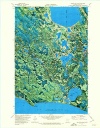
1971 Map of Pigeon Dam Lake
USGS Topo · Published 1974About this map
Lake Winnibigoshish dominates the southern boundary of this early 1970s orthophotomap, where the shoreline at Stony Point meets the dense forest of northern Minnesota. This composite image combines aerial photography with topographic contours, revealing a landscape defined by an intricate network of water bodies, including Round Lake and the connected chain of Upper Pigeon Lake, Middle Pigeon Lake, and Lower Pigeon Lake. The small settlement of Squaw Lake sits at the northern edge, serving as a gateway to the overlapping boundaries of the Chippewa National Forest, Blackduck State Forest, and Bowstring State Forest. Evidence of the local timber and recreation economy is visible in the network of forest roads and the presence of the Farley Hill Lookout Tower, while a remote Cem and a designated Winter Trail speak to the deep-woods character of this Itasca County region.
Find a feature on this map
30 named features on this map. Tap any name to fly to it.
Don’t see what you’re looking for? This feature index may not catch every label — zoom into the map to look around manually.
Map Details
Editions of this 1971 Pigeon Dam Lake Map
This is the sole edition of this map. No revisions or reprints were ever made.
Other maps of this area

1919 · Rosy
USGS Topo · 1:62,500

1919 · Max
USGS Topo · 1:62,500

1954 · Bemidji
USGS Topo · 1:250,000

1957 · Bemidji
USGS Topo · 1:250,000

1958 · Bemidji
USGS Topo · 1:250,000

1971 · Squaw Lake
USGS Topo · 1:24,000

1971 · Dixon Lake
USGS Topo · 1:24,000

1971 · Raven Lake
USGS Topo · 1:24,000
1971 · Dora Lake
USGS Topo · 1:24,000
1971 · Max
USGS Topo · 1:24,000