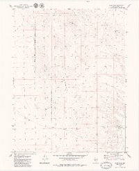
1979 Map of Pilot Cone
USGS Topo · Published 1980About this map
Koegel Hills and the prominent peak of Pilot Cone dominate this high-desert landscape in Mineral County, surveyed in the mid-1970s. The western portion of the map is defined by the Walker River Indian Reservation Boundary, illustrating the intersection of sovereign tribal lands and public domain in this arid region. For those researching the era's mining and water infrastructure, the map identifies a solitary Mine at the northern edge and various Prospects scattered across the hills.
Find a feature on this map
10 named features on this map. Tap any name to fly to it.
Don’t see what you’re looking for? This feature index may not catch every label — zoom into the map to look around manually.
Map Details
Editions of this 1979 Pilot Cone Map
This is the sole edition of this map. No revisions or reprints were ever made.
Other maps of this area

1908 · Carson Sink
USGS Topo · 1:250,000

1909 · Hawthorne
USGS Topo · 1:250,000

1910 · Carson Sink
USGS Topo · 1:250,000

1911 · Hawthorne
USGS Topo · 1:250,000

1915 · Hawthorne
USGS Topo · 1:250,000

1948 · Walker Lake
USGS Topo · 1:250,000

1951 · Allen Springs
USGS Topo · 1:62,500

1957 · Walker Lake
USGS Topo · 1:250,000

1957 · Reno
USGS Topo · 1:250,000

1959 · Reno
USGS Topo · 1:250,000