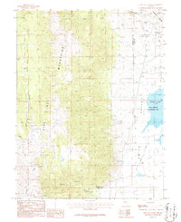
1986 Map of Pine Nut Valley
USGS Topo · Published 1987About this map
The Pine Nut Mountains dominate this 1980s landscape, illustrating a high-desert environment defined by mining exploration and water management. Along the western slopes, Slaters Mine and numerous prospects follow the drainage of Buckeye Creek, while the northeastern corner reveals the Blue Danube Mine and an adit tucked into the Buckskin Range. These mining features are set against a backdrop of complex terrain where the Douglas and Lyon county line traverses the ridges. To the east, the elevation drops sharply into the Smith Valley, where the environment shifts to a managed wetland at the State Wildlife Management Area. This area includes the fluctuating waters of Artesia Lake, a critical desert basin feature. The map provides an insightful look at the infrastructure of the era, including a long-distance Pipeline and several identified gravel pits that served the local region.
Find a feature on this map
18 named features on this map. Tap any name to fly to it.
Don’t see what you’re looking for? This feature index may not catch every label — zoom into the map to look around manually.
Map Details
Editions of this 1986 Pine Nut Valley Map
This is the sole edition of this map. No revisions or reprints were ever made.
Other maps of this area

1889 · Markleeville
USGS Topo · 1:125,000

1891 · Carson
USGS Topo · 1:125,000

1891 · Markleeville
USGS Topo · 1:125,000

1891 · Wabuska
USGS Topo · 1:125,000

1891 · Wellington
USGS Topo · 1:125,000

1893 · Carson
USGS Topo · 1:125,000

1893 · Markleeville
USGS Topo · 1:125,000

1893 · Wellington
USGS Topo · 1:125,000

1894 · Wabuska
USGS Topo · 1:125,000

1948 · Walker Lake
USGS Topo · 1:250,000