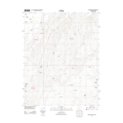
2013 Map of Pinkerton Mesa
USGS Topo · Published 2013About this map
Marvel sits at the northwestern edge of this high-altitude landscape, where the high desert terrain transitions into a complex system of plateaus and deep drainage channels. The geography is dominated by prominent landforms such as Red Mesa and the namesake Pinkerton Mesa, which separate broad alluvial areas like Long Glade from narrow, steep-walled passages including Cannibal Canyon and Valencia Canyon. Evidence of volcanic activity is visible in the southwestern corner, marked by Cinder Butte and the Cinder Bluffs. This era shows a network of regional roads like Co RD 133 and Bureau of Indian Affairs routes such as Indian Rte 111, which navigate between family-named landmarks like Orrie Walker Flat and Clyde Walker Canyon. The hydrography of the region is defined by ephemeral washes and gulches, most notably McDermott Arroyo and Godby Wash, which illustrate the natural drainage patterns of this arid borderland between Colorado and New Mexico.
Find a feature on this map
45 named features on this map. Tap any name to fly to it.
Don’t see what you’re looking for? This feature index may not catch every label — zoom into the map to look around manually.
Map Details
Editions of this 2013 Pinkerton Mesa Map
This is the sole edition of this map. No revisions or reprints were ever made.
Other maps of this area

1889 · Largo
USGS Topo · 1:250,000

1889 · Chaco
USGS Topo · 1:250,000

1892 · Chaco
USGS Topo · 1:250,000

1895 · Largo
USGS Topo · 1:250,000

1908 · Ignacio
USGS Topo · 1:125,000

1913 · Red Mesa
USGS Topo · 1:62,500

1924 · Ignacio
USGS Topo · 1:125,000

1945 · Durango
USGS Topo · 1:250,000

1953 · Durango
USGS Topo · 1:250,000

1954 · Durango
USGS Topo · 1:250,000