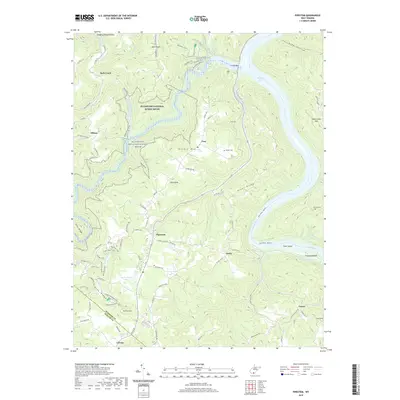
2019 Map of Pipestem
USGS Topo · Published 2019About this map
Bluestone National Scenic River winds through the deep gorges of Summers and Mercer counties, illustrating a landscape defined by the confluence of the Bluestone River and the New River. Small settlements like Pipestem and True occupy the higher ridges, connected by winding mountain roads such as Co Rte 20. The map reveals a high concentration of recreational and natural preservation infrastructure, including the Overlook Trail and Big Pine Trail, which offer access to the wild corridors of Suck Creek and Pipestem Creek. Near the southern boundary, the settlement of Lerona marks the transition toward flatter plateau land. Along the river bottoms, locations like Crumps Bottom and Farley sit near Bull Falls, showing the historic importance of these waterways for navigation and early transit. Family history is preserved at the Snider Cemetery and Barton Cemetery, while Sun Valley Lake represents more modern water management in this high-elevation terrain.
Find a feature on this map
95 named features on this map. Tap any name to fly to it.
Don’t see what you’re looking for? This feature index may not catch every label — zoom into the map to look around manually.
Map Details
Editions of this 2019 Pipestem Map
This is the sole edition of this map. No revisions or reprints were ever made.
Other maps of this area

1887 · Pocahontas
USGS Topo · 1:125,000

1887 · Hinton
USGS Topo · 1:125,000

1890 · Dublin
USGS Topo · 1:125,000

1891 · Pocahontas
USGS Topo · 1:125,000

1891 · Dublin
USGS Topo · 1:125,000

1891 · Raleigh
USGS Topo · 1:125,000

1892 · Hinton
USGS Topo · 1:125,000

1894 · Pocahontas
USGS Topo · 1:125,000

1895 · Pocahontas
USGS Topo · 1:125,000

1897 · Raleigh
USGS Topo · 1:125,000